

Heard on the news that the Brazos River is under a flood warning/advisory. For those that attended the 2006 National in West Columbia,Texas, we passed over the Brazos River upon nearing Columbia Lakes Resort. Rosharon, 18 miles away, is under a flood warning. Hoping to hear our Texas members Robin, Tom E., and others check in ok. Looks like the bass ponds are going to get a little flushing action.
Dallas is under a watch/warning so I'm hoping our friends there are ok too.
Hope Everyone in TX is Safe
-
Jerry J in OK
- Super Board Poster
- Posts: 642
- Joined: Mon Oct 17, 2005 9:56 am
- Location: Duncan, OK
-
Robyn Summerlin

- Advanced Board Poster
- Posts: 332
- Joined: Sun Sep 21, 2003 11:22 am
- Location: Woodville, TX
Thanks for the concern, Brian. My place is far enough east of the flooding to have anything other than soggy ground but El, Ron Mc and others are closer to Ground Zero. The Texas Hill Country is as far ahead of its annual average rainfall this year--some 17 inches--as the southeastern states are behind in theirs.
Robyn
Robyn
-
Ron Mc

- Star Board Poster
- Posts: 3401
- Joined: Thu Apr 29, 2004 7:49 am
- Location: downtown Bulverde, Texas
- Contact:
I like these wet years
I'm in the Hill Country - it runs off quicky here.
this is Texas.
before the hurricane that rained so hard on Houston 4 or 5 years ago, the North American rainfall record was Goldwaite, TX - north of Austin. It was 1932, a 36" rainfall overnight.
All of that drained through the Colorado R. and Austin. I've seen 1st Street underwater more than once.
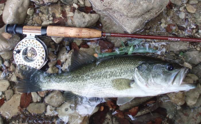
This is White Oak Crossing at the Pedernales headwaters 2 days after a 2000 cfs flood.
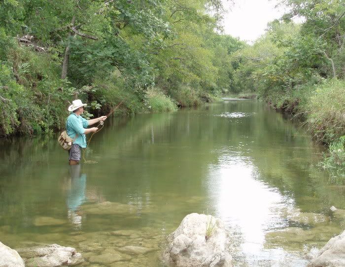
the fishing was great, because the bass come up looking for minnows injured by the high flows.
I caught this bass twice this day.
Check this out - these gauges are about 15-20 miles apart.
Sabinal River - pretty much steady at 100 cfs, maybe a 2-inch rise in the river
http://waterdata.usgs.gov/tx/nwis/uv/?s ... 0065,00060
Frio River - this part of the river is about 15 miles to the west of the upper Sabinal
http://waterdata.usgs.gov/tx/nwis/uv/?s ... 0065,00060
Crested at 18' and 40,000 cfs.
that is how it rains in TX.
It's nothing to have a 60,000' thunderhead turn on the streetlights at noon, not rain on you, but rain several inches on the next block.
I was in Austin, Memorial Day, 81, when we received 7 inches within an hour.
In 2002 we had a 22" overnight at my house here in Bulverde - no flooding at the house, though - I believe we're good.
here's an interesting link
http://orcaonline.org/images/pixel.gif
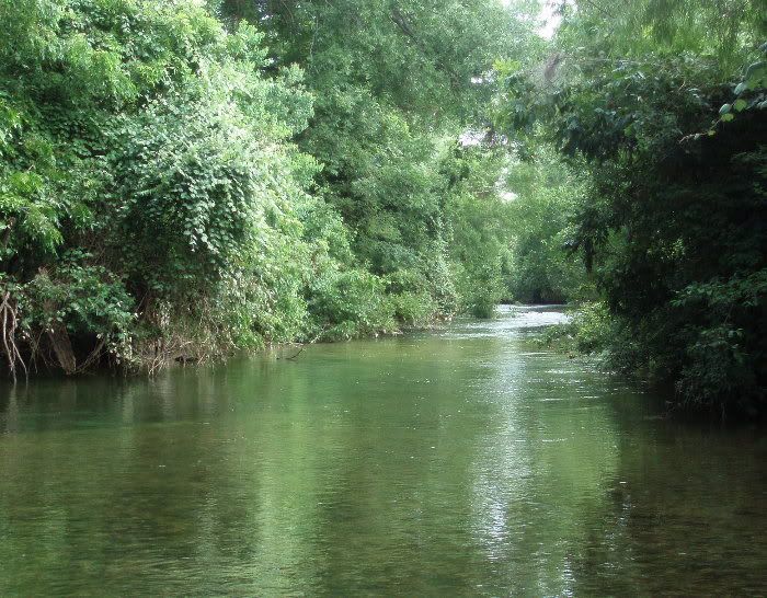
here was Cibolo Creek yesterday morning.
There had been a 9-ft, 2000 cfs wash through here in the middle of last week
The water was already clear, was running 80 cfs which is brisk for this little water, but I caught 4 dozen fish, including a very old Rio Grande cichlid

there was a 3000 cfs, 11-foot wash a few hours after I took these photos.
Give it a couple of days, it will fish fine again.
http://waterdata.usgs.gov/tx/nwis/uv/?s ... 0065,00060
we were fishing under a flash flood warning here:
http://fiberglassflyrodders.com/forum/
not to downplay the severity of TX floods, because they are a fact.
But like I said, this is Texas - they're a fact.
And I love living here - I wouldn't live any place else. We fish 12 months/year. Two days after any rain (ends) I can find clear, fishable water within 90 minutes of home.
this is Texas.
before the hurricane that rained so hard on Houston 4 or 5 years ago, the North American rainfall record was Goldwaite, TX - north of Austin. It was 1932, a 36" rainfall overnight.
All of that drained through the Colorado R. and Austin. I've seen 1st Street underwater more than once.
This is White Oak Crossing at the Pedernales headwaters 2 days after a 2000 cfs flood.
the fishing was great, because the bass come up looking for minnows injured by the high flows.
I caught this bass twice this day.
Check this out - these gauges are about 15-20 miles apart.
Sabinal River - pretty much steady at 100 cfs, maybe a 2-inch rise in the river
http://waterdata.usgs.gov/tx/nwis/uv/?s ... 0065,00060
Frio River - this part of the river is about 15 miles to the west of the upper Sabinal
http://waterdata.usgs.gov/tx/nwis/uv/?s ... 0065,00060
Crested at 18' and 40,000 cfs.
that is how it rains in TX.
It's nothing to have a 60,000' thunderhead turn on the streetlights at noon, not rain on you, but rain several inches on the next block.
I was in Austin, Memorial Day, 81, when we received 7 inches within an hour.
In 2002 we had a 22" overnight at my house here in Bulverde - no flooding at the house, though - I believe we're good.
here's an interesting link
http://orcaonline.org/images/pixel.gif
here was Cibolo Creek yesterday morning.
There had been a 9-ft, 2000 cfs wash through here in the middle of last week
The water was already clear, was running 80 cfs which is brisk for this little water, but I caught 4 dozen fish, including a very old Rio Grande cichlid
there was a 3000 cfs, 11-foot wash a few hours after I took these photos.
Give it a couple of days, it will fish fine again.
http://waterdata.usgs.gov/tx/nwis/uv/?s ... 0065,00060
we were fishing under a flash flood warning here:
http://fiberglassflyrodders.com/forum/
not to downplay the severity of TX floods, because they are a fact.
But like I said, this is Texas - they're a fact.
And I love living here - I wouldn't live any place else. We fish 12 months/year. Two days after any rain (ends) I can find clear, fishable water within 90 minutes of home.
Yo RonMc-Beautiful creek! The flood hydrograph shown for the Frio has an amazingly rapid decline in discharge after maximum. We have far more and higher hills here in Middle Tennessee, but the reason the hydrographs here show a longer duration decline curve is due, in part, to the deep, cherty residuum that acts as a big sponge-but only for streams on the Highland Rim underlain by Mississippian silicastone (Fort Payne Formation, named for Fort Payne Alabama outcrops). Keep fishin' but do pay attention to flash flood warnings. You can't outwit them! BB
PS Also difficult to believe those rivers are just 15 miles apart. Either the rains missed one watershed or the geology-terrain of each is very different.
PS Also difficult to believe those rivers are just 15 miles apart. Either the rains missed one watershed or the geology-terrain of each is very different.
-
Ron Mc
- Star Board Poster
- Posts: 3401
- Joined: Thu Apr 29, 2004 7:49 am
- Location: downtown Bulverde, Texas
- Contact:
probably more of the former, but the latter could also be a factor - most of these headwaters are bare dolomite, except the Pedernales, which is granite. Mostly, though, it's Texas rain.
yes, most of these headwaters are fishable just a day or so after serious runoff like that.
flash floods? yes, that's why I read the nexrad links as well as the usgs.
If there's a flash flood watch, and especially warning, I park high and am very conscious with my exploring
yes, most of these headwaters are fishable just a day or so after serious runoff like that.
flash floods? yes, that's why I read the nexrad links as well as the usgs.
If there's a flash flood watch, and especially warning, I park high and am very conscious with my exploring